A copy of this work was available on the public web and has been preserved in the Wayback Machine. The capture dates from 2017; you can also visit the original URL.
The file type is application/pdf.
Filters
Interpretation of buildings in high resolution sar images based on electromagnetic method
2010
2010 IEEE International Geoscience and Remote Sensing Symposium
Preserved Fulltext

In order to thoroughly understand the backscattering behaviour of building targets in high resolution SAR images, analysis and experiments were carried out in this paper based on electromagnetic scattering ...
of building target could be more thoroughly explained based on the electromagnetic method. ...
doi:10.1109/igarss.2010.5649761
dblp:conf/igarss/ZhangSWZ10
fatcat:bi7uwgjzdfd4vc2c2kpp3dhkbe
Model-Based Interpretation of High-Resolution SAR Images of Buildings
2008
IEEE Journal of Selected Topics in Applied Earth Observations and Remote Sensing
Preserved Fulltext

A copy of this work was available on the public web and has been preserved in the Wayback Machine. The capture dates from 2017; you can also visit the original URL.
The file type is application/pdf.
High resolution (HR) Synthetic Aperture Radar (SAR) images of urban areas reveal a large variety of details that, although potentially bringing a lot of information, are often very difficult to interpret ...
A meaningful case-study is presented to show that the main features appearing on the SAR image of a building can be interpreted by using our geometric and electromagnetic model. ...
ACKNOWLEDGEMENTS The authors would like to thank the Microwaves and Radar Institute, German Aerospace Center (DLR) for providing the E-SAR data of Munich. ...
doi:10.1109/jstars.2008.2001155
fatcat:6k2g3uu5u5f47nzyjyhat4vczq
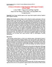
A Study on Simulation of High Resolution SAR Image of Complex Ground Target
2017
DEStech Transactions on Computer Science and Engineering
Preserved Fulltext
A copy of this work was available on the public web and has been preserved in the Wayback Machine. The capture dates from 2018; you can also visit the original URL.
The file type is application/pdf.
challenges in the interpretation of the SAR image. ...
A simulator method based on electromagnetic scattering characteristics of the target was presented to obtain SAR image of targets on the ground. ...
SAR Image Simulation Based on Turntable Imaging Principle According to the theory of radar imaging, high range resolution can be obtained by transmitting broadband signal and the high azimuth resolution ...
doi:10.12783/dtcse/itme2017/7970
fatcat:z3zlvawcovg35fesy2cbpz3gvq
A new algorithm for building feature extraction from single amplitude SAR images
2013
2013 IEEE International Geoscience and Remote Sensing Symposium - IGARSS
Preserved Fulltext

A copy of this work was available on the public web and has been preserved in the Wayback Machine. The capture dates from 2017; you can also visit the original URL.
The file type is application/pdf.
In this paper we present first results regarding the analysis of individual business district buildings on very high resolution SAR images. ...
The algorithm is applied on a spotlight high resolution image of the business center of Naples, Italy. Index Terms-SAR, urban areas, spectral estimation. ...
Stilla, "Model-Based Interpretation of High-Resolution SAR Images of Buildings", IEEE 1. Sel. Topics App l. Earth Observ., vol. 1, no. 2, pp. 107-119, June 2008. [3] S. Auer, C. Gisinger, and R. ...
doi:10.1109/igarss.2013.6723775
dblp:conf/igarss/MartinoIRR13
fatcat:rukef7yyrfh2ljb46zud7mkany
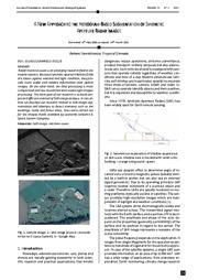
A New Approach to the Histogram-Based Segmentation of Synthetic Aperture Radar Images
2021
Journal of Automation, Mobile Robotics & Intelligent Systems
Preserved Fulltext
A copy of this work was available on the public web and has been preserved in the Wayback Machine. The capture dates from 2021; you can also visit the original URL.
The file type is application/pdf.
The main goal of our reasarch is to build simple and efficient method of SAR image analysis. ...
In this article we describe our research related to SAR image segmenta tion and attempts to detect elements such as the build ings, roads and forest areas. ...
ACKNOWLEDGEMENTS We thank Leonardo Airborne & Space System Company for sharing SAR images and corresponding Google Map. ...
doi:10.14313/jamris/1-2021/5
fatcat:e7mgtqi4yngatdsahacoh7bwne
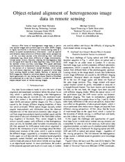
Object-Related Alignment of Heterogeneous Image Data in Remote Sensing
2018
2018 21st International Conference on Information Fusion (FUSION)
Preserved Fulltext
A copy of this work was available on the public web and has been preserved in the Wayback Machine. The capture dates from 2019; you can also visit the original URL.
The file type is application/pdf.
The fusion of heterogeneous image data, in particular optical images and synthetic aperture radar (SAR) images, is highly worthwhile in the context of remote sensing tasks as it allows to exploit complementary ...
Sections of optical and SAR images are related to individual objects using interpretation layers generated with ray tracing techniques. ...
The TerraSAR-X image in Fig. 1b relies on signals in the X-Band of the electromagnetic spectrum (wave length: 3.1cm) and is captured in high-resolution spotlight mode, where the time for image capturing ...
doi:10.23919/icif.2018.8455364
dblp:conf/fusion/AuerR018
fatcat:sjs5qcz6obcndh2qo56vryenn4
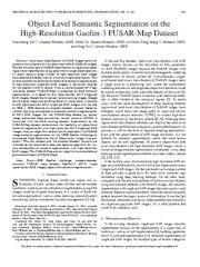
Object-Level Semantic Segmentation on the High-Resolution Gaofen-3 FUSAR-Map Dataset
2021
IEEE Journal of Selected Topics in Applied Earth Observations and Remote Sensing
Preserved Fulltext
A copy of this work was available on the public web and has been preserved in the Wayback Machine. The capture dates from 2021; you can also visit the original URL.
The file type is application/pdf.
In recent years, a large number of high-resolution SAR images have become available, most of which are single-polarization. ...
It consists of 610 high-resolution GF-3 single-pol SAR images with the size of 1024 × Second, an encoder-decoder network based on transfer learning is employed to implement semantic segmentation of GF- ...
Liu for helping to complete the work of image registration. ...
doi:10.1109/jstars.2021.3063797
fatcat:drj2psblnbfmjbbmmem7lxaddm
A stochastic model for very high resolution SAR amplitude images of urban areas
2014
2014 IEEE Geoscience and Remote Sensing Symposium
Preserved Fulltext
A copy of this work was available on the public web and has been preserved in the Wayback Machine. The capture dates from 2017; you can also visit the original URL.
The file type is application/pdf.
However, due to the involved electromagnetic mechanisms dictating SAR image formation, direct interpretation of very high-resolution (VHR) SAR images is not straightforward. ...
For the new generation of spaceborne SAR sensors a resolution even better than one meter in the spotlight acquisition mode can be obtained. ...
ACKNOWLEGEMENT This work was supported by ASI in the framework of the AO project "Buildings feature extraction from single SAR images: application to Cosmo/SkyMed high resolution SAR images." ...
doi:10.1109/igarss.2014.6946581
dblp:conf/igarss/MartinoIRR14
fatcat:hiwtc7aypvcppkudhx3mxp6xoq
Application of feature modelling method based on SAR image in target interpretation
2019
The Journal of Engineering
Preserved Fulltext
A copy of this work was available on the public web and has been preserved in the Wayback Machine. The capture dates from 2022; you can also visit the original URL.
The file type is application/pdf.
The actual results show that the target interpretation method based on SAR imaging feature modelling proposed here can effectively improve the target recognition rate . ...
At the same time, the high-frequency electromagnetic scattering calculation method is used to predict the 3D hot spot distribution of each candidate target, to improve the recognition accuracy of the target ...
However, compared with the rapid growth of SAR data sources, the research of SAR application technology based on SAR image interpretation is lagging behind. ...
doi:10.1049/joe.2019.0206
fatcat:x5ld3zznxvbdnaj7pufsjqnahu
TOWARDS A SEMANTIC INTERPRETATION OF URBAN AREAS WITH AIRBORNE SYNTHETIC APERTURE RADAR TOMOGRAPHY
2016
ISPRS Annals of the Photogrammetry, Remote Sensing and Spatial Information Sciences
Preserved Fulltext
A copy of this work was available on the public web and has been preserved in the Wayback Machine. The capture dates from 2019; you can also visit the original URL.
The file type is application/pdf.
Second, building facades and roofs are extracted thanks to geometric classification rules. We demonstrate our method on a 3 image L-Band airborne dataset over the city of Dresden, Germany. ...
In this paper, we introduce a method to detect and reconstruct building parts from tomographic Synthetic Aperture Radar (SAR) airborne data. ...
ACKNOWLEDGEMENTS The authors would like to thank DLR for providing the E-SAR data. This work was supported by the German Science Foundation DFG, under project No. DH 75/2-1. ...
doi:10.5194/isprs-annals-iii-7-235-2016
fatcat:ay4rxcubjrh3hkhloxphnswdjm
TerraSAR-X StripMap Data Interpretation of Complex Urban Scenarios with 3D SAR Tomography
2014
Journal of Sensors
Preserved Fulltext
A copy of this work was available on the public web and has been preserved in the Wayback Machine. The capture dates from 2019; you can also visit the original URL.
The file type is application/pdf.
In this paper, we use 3D SAR tomography for SAR data interpretation of dense urban areas. ...
The severe layover problem of complex urban scenarios in SAR data makes SAR data interpretation very difficult, especially for nonexperts. ...
This work is financially supported by the National Natural Science Foundation of China under Grants 41174120 and 61331016, and the Research Fund for the Doctoral Program of Higher Education of China under ...
doi:10.1155/2014/386753
fatcat:jf4x7rpiejamnl7nbsstzsq6fa
Introducing the March Issue [From the Editor]
2021
IEEE Geoscience and Remote Sensing Magazine
Preserved Fulltext

A copy of this work was available on the public web and has been preserved in the Wayback Machine. The capture dates from 2021; you can also visit the original URL.
The file type is application/pdf.
Statistical models are important for the automatic processing of SAR images and simplifying the interpretation of electromagnetic scattering models, representing the result of more complex scattering mechanisms ...
The final feature related to radio frequency methods is a tutorial on high-resolution surveying with smallloop FDEM systems. ...
The final feature related to radio frequency methods is a tutorial on high-resolution surveying with smallloop FDEM systems. ...
doi:10.1109/mgrs.2021.3056862
fatcat:jkw6zebkkrbulaonlxhtjnca6e
BUILDING HEIGHT ESTIMATION FROM HIGH RESOLUTION SAR IMAGERY VIA MODEL-BASED GEOMETRICAL STRUCTURE PREDICTION
2015
Progress In Electromagnetics Research M
Preserved Fulltext
A copy of this work was available on the public web and has been preserved in the Wayback Machine. The capture dates from 2017; you can also visit the original URL.
The file type is application/pdf.
According to the analysis on the building geometrical properties in the SAR imagery, a novel height estimation algorithm is proposed following a model-based geometrical structure prediction and matching ...
The experimental results with the simulated and real airborne and spaceborne SAR images show that the proposed method could efficiently estimate building height from single SAR imagery, and achieve better ...
This study is supported by the National Natural Science Foundation of China (No. 61105031). ...
doi:10.2528/pierm14073001
fatcat:4thcwfvzsvbhpkntva52xa5x4a
Development of building height data from high-resolution SAR imagery and building footprint
[chapter]
2014
Safety, Reliability, Risk and Life-Cycle Performance of Structures and Infrastructures
Preserved Fulltext

A copy of this work was available on the public web and has been preserved in the Wayback Machine. The capture dates from 2017; you can also visit the original URL.
The file type is application/pdf.
In this study, a new method is developed to detect building heights automatically from a 2D GIS data and a single high-resolution TerraSAR-X (TSX) intensity image. ...
The proposed method is tested on a TSX image of Lima, Peru in the HighSpot mode with a resolution of about 1 m. The result showed a reasonable level of accuracy. ...
These methods, however, require at least two SAR images in different flight angles. The second category is based on a direct electromagnetic backscattering model. ...
doi:10.1201/b16387-798
fatcat:bmaxqiodcrbcza4tiq2li2alhi
Height Retrieval of Isolated Buildings From Single High-Resolution SAR Images
2010
IEEE Transactions on Geoscience and Remote Sensing
Preserved Fulltext
A copy of this work was available on the public web and has been preserved in the Wayback Machine. The capture dates from 2017; you can also visit the original URL.
The file type is application/pdf.
Detection of man-made structures in urban areas, in terms of both geometric and electromagnetic features, from a single, possibly High Resolution (HR), Synthetic Aperture Radar (SAR) image is a highly ...
Some possible applications of feature extractions from real SAR images, based on above approach, have been already presented in literature as first examples of potentiality of a model-based approach but ...
by considering high resolution SAR, this measurement error on φ is smaller. ...
doi:10.1109/tgrs.2010.2041460
fatcat:bq3by5qoijabpdlvxtjcue6rdm
« Previous
Showing results 1 — 15 out of 3,254 results